10 best hikes around Phoenix for experienced hikers
Phoenix really does have one of the country’s best hiking scenes. Last week, I recommended the best hikes around Phoenix for beginners. This week’s challenge was to name the best hikes around Phoenix for experienced hikers. Not an easy task. Eventually, I settled on ten hikes that would be at the top of my list if I were visiting the valley. In order of difficulty, these are the hikes that I’ve missed the most–and the trails that I recommend most to avid hikers who find themselves in the Phoenix area for work or for play.
Peralta Trail (Superstitions)
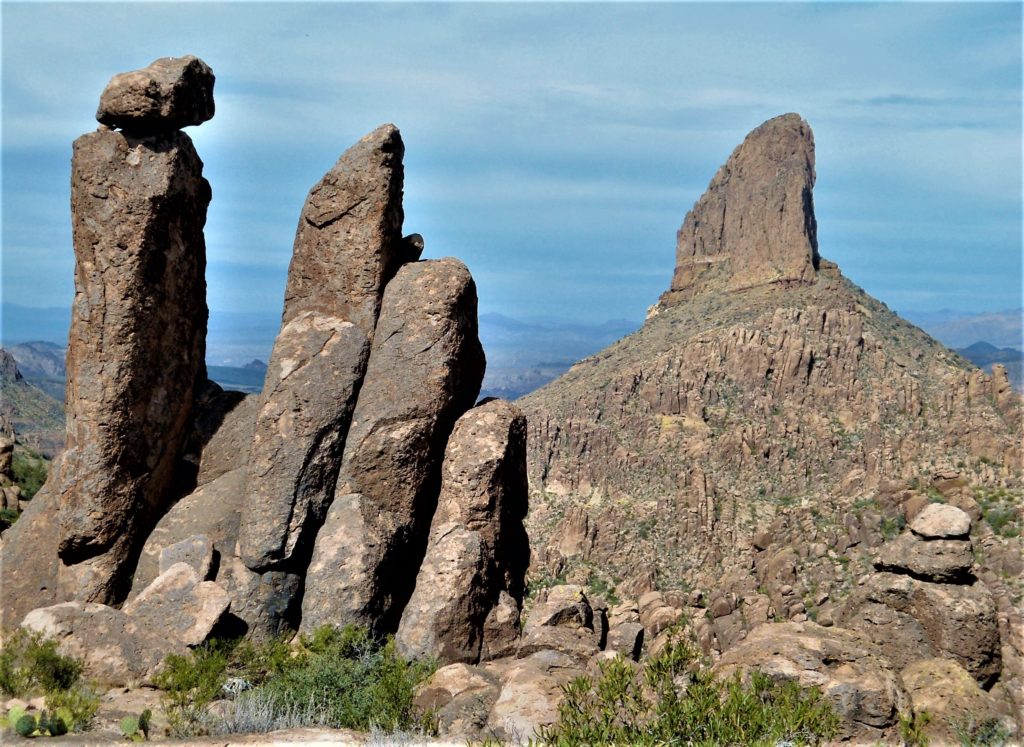
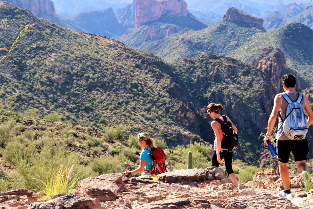
Peralta Trail may be the perfect trail. It starts with two rarities for Arizona: trees and water (seasonal). Then it meanders up a scenic canyon guarded by hundreds of hoodoos standing like sentinels on the ridges. You’ll leave the riparian area, cross the creek, switchback, and tramp past funky rock formations on your climb to Peralta saddle (2.5 miles). Enjoy the money shot of Weaver’s Needle and panoramic views of the Superstition Wilderness to the north. The view going down doesn’t suck, either, with an expansive vista of Peralta Canyon and distant mountains to the south. This isn’t an easy hike, given the elevation gain. But it’s the most accessible trail into the Superstition Mountains and deservedly one of the most popular hikes outside Phoenix.
Moderate: ~5 miles/1400 ft. elevation gain (net)
Peralta Trailhead: Peralta Rd, Gold Canyon, AZ 85118 (1 hr E of Phoenix)
Holbert Trail (South Mountain)
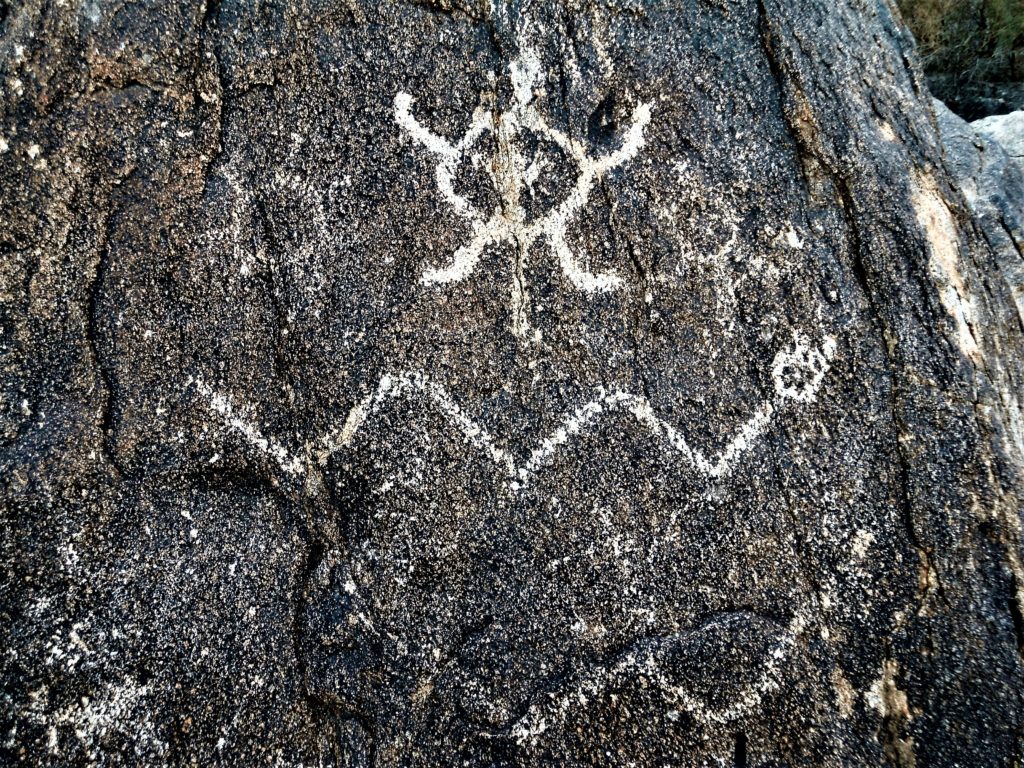
The Holbert Trail is another one of the best hikes around Phoenix. Like Peralta Trail, the Holbert Trail packs a lot into a relatively short distance. You’ll warm up with an easy walk through a valley decorated with Hohokam petroglyphs. Once you to start the climb, however, it’s on! You’ll gain more than 1000 feet over the next mile and a half as you scale a natural stone staircase up South Mountain. Holbert Trail tops out near Dobbin’s Lookout (short right turn), where hikers score a postcard shot of the Phoenix skyline before returning the way they came. This trail’s been here for at least 800 years, and it’s definitely one the best hikes around Phoenix for petroglyphs, city views, and a short but strenuous climb.
Moderate: ~5 miles/1100 ft. elevation gain
Trailhead: 10919 S. Central Ave Phoenix (South Mountain)
Tom’s Thumb (McDowell Mts)
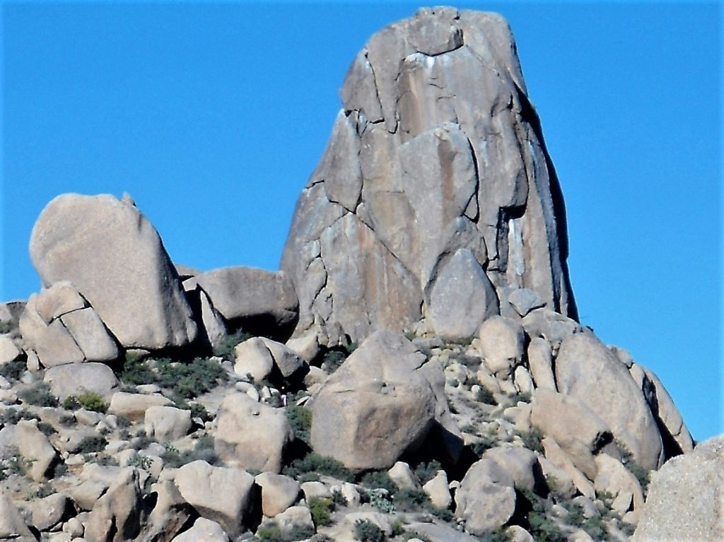
Most people in the valley can recognize Tom’s Thumb–the distinctive rock tower jutting from the McDowell Mountains. The Tom’s Thumb Trail was one of my favorite short hikes around Phoenix. Starting from the Tom’s Thumb Trailhead in (far) North Scottsdale, you’ll enjoy an easy warm up on the desert floor before making an aggressive climb up gravelly switchbacks to a scenic saddle. From here, the trail mellows out a bit as it snakes its way through weathered granite boulders, crosses a scenic ridge, and finishes with a moderate ascent to the base of Tom’s Thumb. Enjoy commanding views of the Sonoran desert from a giant boulder, or catch some shade in the “cave” near the Thumb. Reverse your route for an out-and-back hike. You’ll make great time going down, but watch your footing on the knee-burning switchbacks as you weave your way back to the trailhead.
Moderate: 4.5 miles/ 1100 ft elevation gain
Tom’s Thumb Trailhead: 23015 N 128th St, Scottsdale, AZ 85255
Bell Pass (McDowell Mts)
With moderate gradient mixed with some switchbacks, Bell Pass is one the best hikes around Phoenix to squeeze in more miles and elevation gain. To reach Bell Pass, start on the Saguaro trail from the Gateway Trailhead and begin the Gateway Loop counter-clockwise (right). Around 1.5 miles, turn right onto Bell Pass Trail for a steady climb that eventually switchbacks to the saddle. Retrace your steps for a great out-and-back hike (7 miles/1500 ft elevation gain)–or take the long way back via the Bell Pass-Windgate Trail Loop (9.5 miles). To complete this counter-clockwise loop, continue from the saddle on Bell Pass Trail (northeast), eventually turning left onto the Windgate Trail and continuing on Gateway Trail back to the trailhead. Once you get outside the popular Gateway Loop in this park, you’ll often have the trail to yourself. Enjoy the exercise, the solitude, and rare glimpses of reclusive animals, like desert tortoises.
Location: Gateway Trailhead, McDowell Sonoran Nature Preserve (Scottsdale)
Barnhardt Trail (Mazatzals)
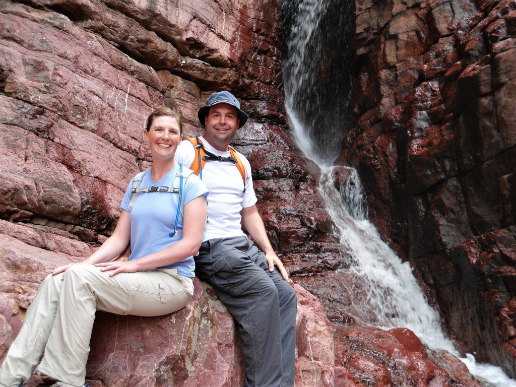
Much like Bell Pass, the Barnhardt Trail hits that sweet spot where the elevation adds up faster than you realize. And the scenery is great, too, as you zig through a colorful canyon and zag past intricate rock panels as you climb toward (seasonal) waterfalls in the upper canyon. If you can time this hike after rain or winter snow, you’ll enjoy the sights and sounds of running water. For a nice out-and-back hike, turn around at Barnhardt falls (pictured above) for a 7 mile round trip with almost 1800 feet of elevation gain. (If you’re a masochist, you can try to reach the mountaintop, but expect the upper trail to be overrun with unforgiving vegetation that’s hellbent on maiming hikers.) This is the best moderate hike in the Mazatzal Mountains–and well worth the one hour drive from Phoenix.
Barnhardt Trailhead: N on 87 (Beeline Highway); left (west) on Forest Road 419 (gravel) for 5 miles to Barnhardt Trail #43
Camelback Mountain (Phoenix)
Camelback Mountain is one of the best urban hikes in the country. It’s a fun and strenuous gauntlet of switchbacks, slick rock, and scrambling that deserves its popularity. And its notoriety: Camelback has more rescues and fatalities than any other mountain in the valley. (See the city’s safety tips for desert hiking: Take a Hike. Do it Right.) If you’re fit and acclimated to the desert, however, you’ll enjoy scaling the switchbacks and boulders to the summit. Opt for the Echo Canyon trail for the steepest (and most popular) route to the top (2.5 miles round trip/1300 ft elevation gain). Choose the Cholla Trail for a slightly easier gradient–but more exposed scrambling. If you’re physically ready for Camelback, you’ll see why it’s arguably the city’s best hike.
Rating: Difficult
Echo Canyon Trailhead: 4925 E. McDonald Dr (extremely busy)
Cholla Trailhead: Park on Invergordon Road (64th St) & walk up Cholla Lane to trailhead. (busy with extra 1/2 mile walk to & from trailhead)
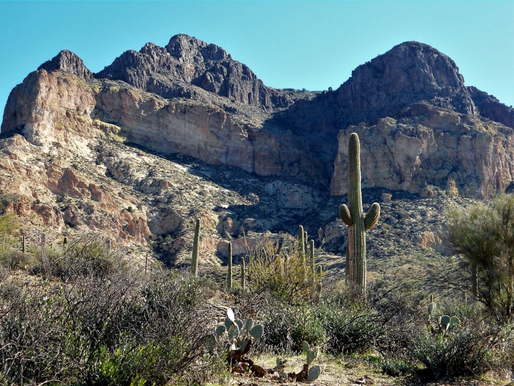
Boulder Canyon-LaBarge Box (Superstitions)
Boulder Canyon is a scenic route into the northern Superstitions. Up top, you’ll enjoy unique views of Canyon Lake, Battleship Mountain, Weaver’s Needle, and Superstition peak. In the depths of the canyon, you’ll rock-hop your way across a couple miles of desert wash with seasonal water. Near the end of the wash, veer left and bush-whack your way to LaBarge Box to enjoy a secluded swimming hole. Retrace your steps for a moderate out-and-back hike–or add a side trip to Battleship Mountain for some difficult scrambling up and down an exposed ridgeline. With rock-hopping, scrambling, swimming, and killer views of the Superstitions, the Boulder-LaBarge hike is a great choice for seasoned desert hikers.
Moderate/Difficult: ~ 10 miles (difficult footing, significant accumulated elevation gain)
Boulder Canyon Trailhead: Canyon Lake Marina (Apache Junction)
Picketpost Mountain (Superior, AZ)
Picketpost Mountain is the complete and utter badass off Highway 60 East with the broad shoulders and menacing cliffs. This mountain was made for desert bighorn sheep–not people. However, experienced hikers can scale this bad boy on a faint and difficult trail up the mountain’s western face. To reach the summit, you’ll pass through a wash and stand of saguaros, scale a rock wall or two, slide across a scree slope, and scramble up a slick rock gully to reach the mountain’s flat summit. (It’s not hard to get lost.) Wander the mountaintop until you find Picketpost’s famous mailbox. You’ve done it! (Now you’ve just got to get back down without taking a tumble…) Avid hikers will enjoy the physical challenge of Picketpost and its big-time views of the Superstitions.
Difficult: ~4.4 miles (round trip)/2000 ft elevation gain
Picketpost Trailhead: Access via Forest Road 231 off U.S. 60 east
Brown’s Peak (Four Peaks)
The highest summit around Phoenix is Brown’s Peak (7,657 ft)–the tallest of the Four Peaks. Brown’s Peak is a challenging hike. The first challenge is not getting carsick (or driving off a cliff) on the gravel road to the trailhead. From the trailhead, there’s a moderate climb to a scenic saddle through thickets of manzanitas and pines. No problem. (Just watch out for Arizona Black Rattlesnakes.) From the saddle, however, you need to scramble up a narrow scree chute and rock wall to reach a second saddle that leads to the summit. This climb is physically demanding and potentially dangerous, due to loose rocks in the chute. (Hikers should bunch together here to minimize the risk of being injured or killed by cascading rocks.) If you can summit Brown’s Peak, however, you’ll have stunning views of Arizona that can span more than three hundred miles on clear days.
Directions: Take FR143 (gravel) 20 miles to Lone Pine Trailhead/Brown’s Peak Trail #133
Difficult: ~ 5 miles/2000 ft elevation gain (class 3/4 scrambling)
Siphon Draw-Flat Iron (Superstitions)
Outside of the Superstition Ridgeline, Flat Iron is the most difficult day hike around Phoenix. And the best day hike in the Superstitions. You start from Siphon Draw Trailhead on an obvious trail. Once the trail heads up the mountain, however, Siphon Draw becomes a continuous scramble…up 3000 feet of Superstition Mountain. This trail’s got a bit of everything: wildflowers, cactus, slick rock, scree, switchbacks, an airplane crash, a rock wall, and a scenic overlook from the top of Flatiron. I don’t savor many summits, but I do savor this one. Enjoy the views–you’ve earned them! (Maybe pack a celebratory IPA?!) And psyche yourself up for the return trip. It’s not as tiring going down, but parts of the descent will be harder and more dangerous than the climb up. This is a fun and demanding trail for experienced hikers.
Difficult: ~6 miles/3000 feet elevation gain
Siphon Draw Trailhead: 6109 E Apache Trail, Apache Junction, AZ 85119
Happy Trails!
These trails are not for everybody. They are strenuous and potentially dangerous, especially in the heat. Each year, people die as they hike in the Superstitions or climb Camelback Mountain. Even experienced desert hikers can struggle with the heat, take a fall, or accidentally get off trail. If you’re a seasoned hiker who’s acclimated to the desert, however, you’ll have a hard time beating these ten trails in the greater Phoenix area. Give them a try! And let me know what you think in the comments below: Which hikes were your favorites? What Phoenix-area hikes make your top ten?
Happy Hiking!